Where the water is
Street flood sensors, the deepest spots right now and what that depth means for a car or a motorbike.
- How deep is it?
- Deepest sensors now
- Critical at 20 cm or more
- Flooded roads from the community
 Augma
AugmaLive · refreshed every 5 minutes
One free map for the flood: depth, roads to avoid, rain, canals, shelters, free parking and help requests, for Bangkok and the provinces around it.
Right now
The city, live
Rain, rivers, dams
At the height of it
From the map's hour-by-hour history (the last 48 hours); earlier peaks are kept. The BMA street sensors stopped updating early on 29 Sep, so depth readings after that stay flat.
Impact
The story spread · Instagram reel · 3 days
2,058 shares and 1,176 saves: people passing the map to someone they worry about, and keeping it for the next day.
And what the map is carrying for the city right now
Usage tracking began 27 Sep 16:57, a day after the map went live; counts are browsers, not people.
The problem
Sensors, rain gauges, shelters, traffic and SOS calls each live on a different site, in a different format.
A reading in centimetres doesn't tell you whether to drive, where to park or which shelter still has room.
Water moves, rain arrives and roads close faster than a daily update can keep up with.
The map brings it into one place, turns it into plain answers (avoid, go, park, shelter) and keeps it current every 5 minutes.
How it started
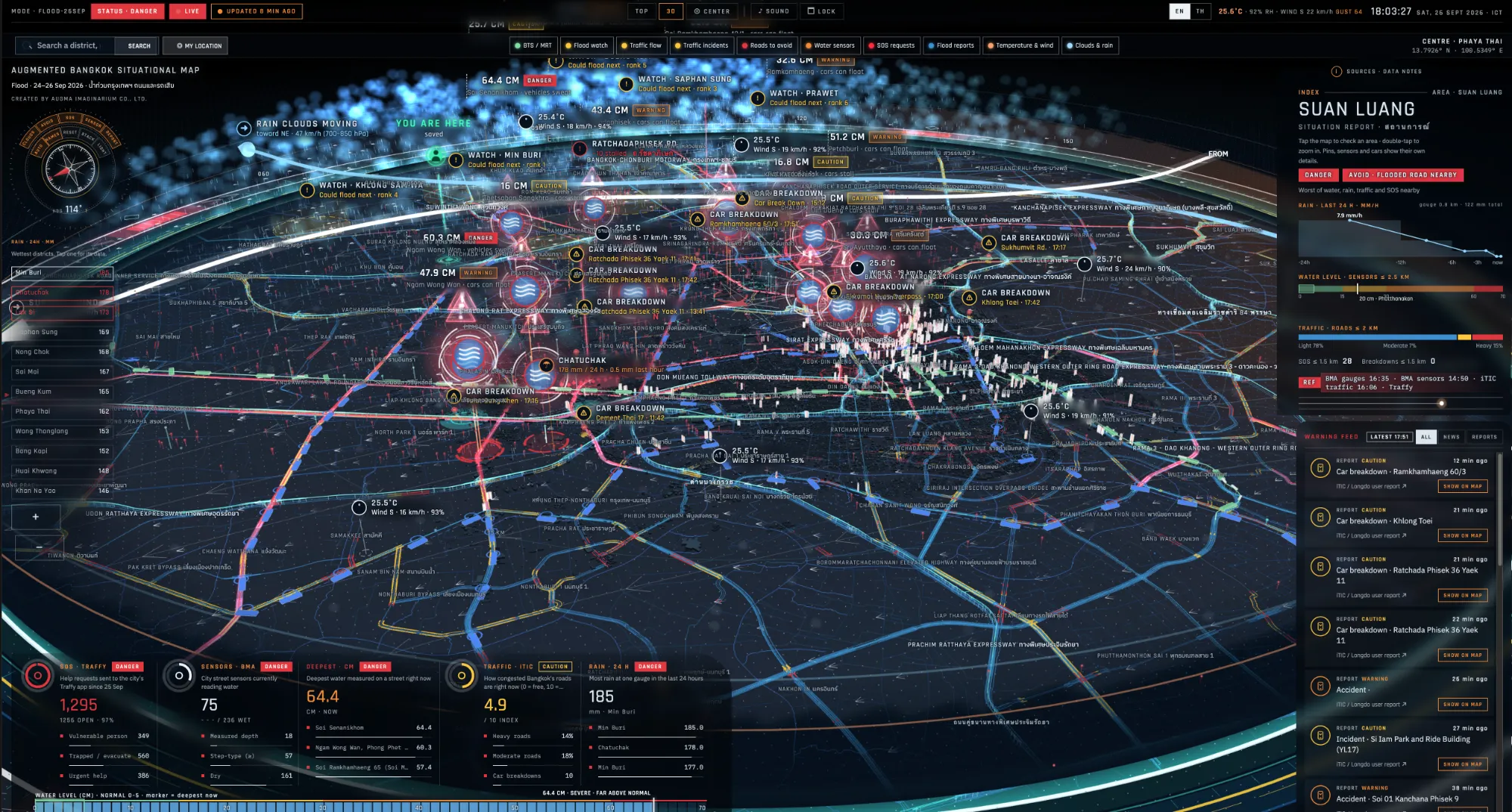
It began as Bangkok drawn as a 3D holographic map, an experiment in showing a whole city's situation at a glance. Then people started using it during the flood, so we kept going: layer by layer, from the sources people told us they needed, until it became a tool to plan a day around the water.
A day on the map
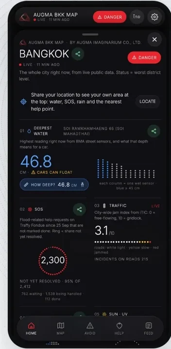
Before anything else, one screen: the deepest water, people asking for help, traffic and rain, each with a short note on what it means, and where every number comes from.
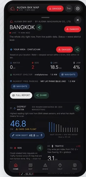
Share your location, only if you choose, and see what is happening near you, the closest shelter and help. Nothing is stored.
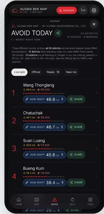
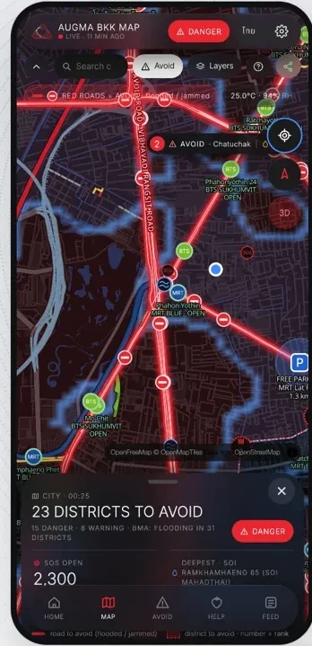
Districts ranked by water, rain, traffic and SOS calls nearby, with the reason shown. Roads reported flooded or jammed are drawn in red, named, so you can plan around them.
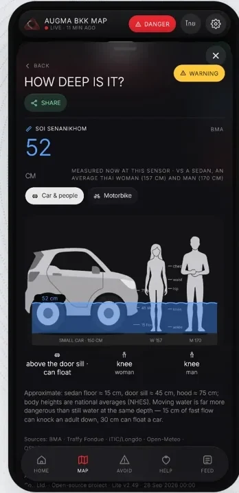
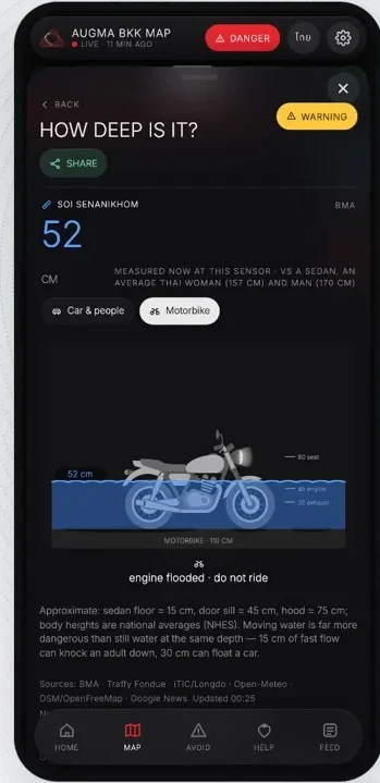
Centimetres are hard to picture, so every reading is drawn next to a car, a person, or a motorbike: above the door sill, knee-deep, engine flooded.
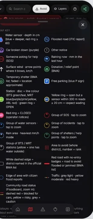
Red is danger, yellow a warning, blue is water, and every symbol is explained. Tap any point, a sensor, a shelter or a road, to see what it means and how to get there.
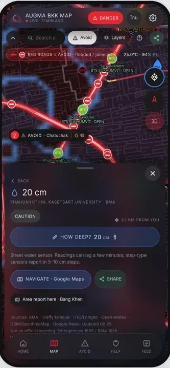
Check your route against the water, and the rain for the next few hours, area by area, so you know when to leave and when to wait.
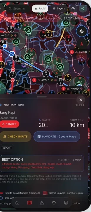
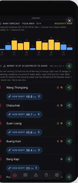
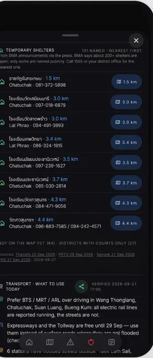
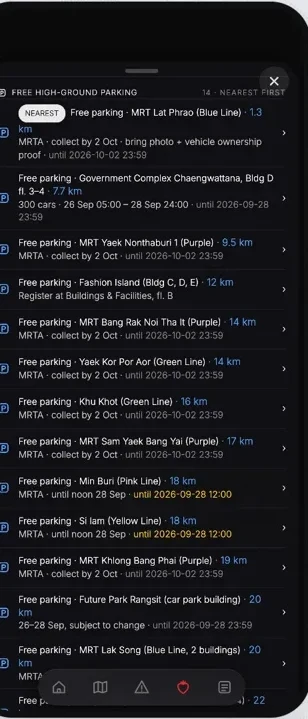
Temporary shelters, nearest first, and whether they are full. Free high-ground parking, with the dates each offer ends.
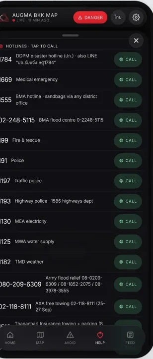
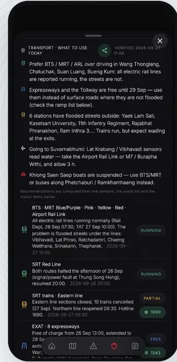
Emergency and help lines in one list, tap to call. Which train lines run and which exits flood, so the day can still go on.
Send ‘I'm safe’ or ‘please check on me’ to family and friends, and simple steps for home, driving, elderly family, pets, and after the water goes down.
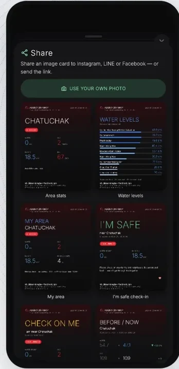
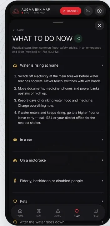
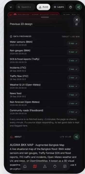
Screens captured from the live app; the numbers are from the moment of capture.
Three streams, one map
Open the data visualization full screen →
Government and public agencies
Measured, official, sometimes slow.
People on the ground
Fast, local, needs checking.
AI
Reads and summarises, never invents.
Counts are what the map holds right now
People helping people
Sensors and public data give the map its shape. People give it the truth on the ground. Every report, photo or ‘this is wrong’ makes the map a little more accurate for the next person, who can then avoid a road, find a shelter, or help someone nearby.
It borrows an idea from games where strangers leave help along the road for people they will never meet: small kindnesses that connect, and add up. A chain of positivity, one report at a time.
Water on your street, a shelter that's full, a road that's clear.
Report in about 30 seconds, with a photo if you like.
Reports and flags feed the district levels and trends.
They avoid a road, reach a shelter, or answer ‘Can you help?’
And share what they see in turn.
K.A.R.A's part

K.A.R.A, our own AI assistant, writes the map's ‘AI summary of the day’ every three hours, only from the data the map itself has published, so what it says can always be traced back to a sensor, a gauge or a report. Alongside it, an hourly AI pass reads the last day of news and turns it into map points for the provinces around Bangkok.
The map itself was built with AI-assisted coding, which is how it went from idea to live in 24 hours.
Meet K.A.R.A →Noticed
Ulrich Buckenlei wrote about the map on LinkedIn: how AI-assisted coding and open data (BMA, Traffy Fondue, iTIC/Longdo, Open-Meteo, OpenStreetMap) produced a working 3D situational map during the flood, and why operational trust still depends on current data, clear labelling of uncertainty and careful validation.
What it can do
Street flood sensors, the deepest spots right now and what that depth means for a car or a motorbike.
Districts and roads ranked by water, rain, traffic and nearby SOS calls, for now and for the rest of today.
Rain gauges, the next 12 hours of forecast, radar, canal and river levels, dam releases and the next high tide.
The nearest shelter (and whether it is full), free high-ground parking, medical, shuttle and food points, and hotlines you can tap to call.
Report what you see in about 30 seconds, with a photo if you like, or flag something that looks wrong. Photos are resized and their location data removed.
Alerts for an area you care about, a daily AI summary written only from the map's own data, and news and official notices, latest first.
Free, no sign-up, Thai and English, high contrast, keeps the last data when you lose signal, and installs to your home screen.
Built on public data
Everything refreshes in the cloud, day and night. A separate check watches every source for freshness; if one fails, the map keeps its last good data and says so.
Covers Bangkok, Nonthaburi, Samut Prakan, Pathum Thani and Samut Sakhon, and the edges of Nakhon Pathom and Chachoengsao.
Is it working?
What we learned
A plain map that is live today helps more than a beautiful one next week. We shipped in 24 hours, then improved it in public, hour by hour.
The street sensors stopped updating early on 29 September. The map kept their last good readings, marked them as old, and leaned on rain gauges and people's reports.
Help requests, community road reports and photos filled the gaps no instrument could. The map's job is to make sharing take seconds.
K.A.R.A only writes from data the map already shows, and every AI line can be traced back to a source. Where AI helps most is sorting a flood of news, fast.
‘52 cm’ means nothing at 6 am. ‘Above the door sill of a car’ does. Every reading is drawn next to something people know.
We point to official lines on every screen. The map helps people decide; the authorities still decide for the city.
What's new
v2.136Version 2.136 of the 2D map, with refinements to the 3D view.
Coverage grows beyond Bangkok: Nonthaburi, Samut Prakan, Pathum Thani and Samut Sakhon, with districts, rain, canals, incidents and reports.
Flood pages for search, in Thai and English, so people find the map when they search for flooding.
The map now refreshes itself in the cloud every 5 minutes, day and night.
Push alerts for an area you save, a photo report from the ground, and an ‘Is this wrong?’ flag on every area.
New layers: canal and river levels, Chao Phraya Dam release, the next high tide and rain radar. Free parking, medical, shuttle and food points join the Help layer.
FAQ
Yes. It is free, needs no sign-up and works on any phone.
The data refreshes in the cloud every 5 minutes; shelter status every 15 minutes.
No. It is a community tool built from public data. In an emergency call 1669 (medical), 1784 (DDPM) or 1555 (BMA).
Bangkok, Nonthaburi, Samut Prakan, Pathum Thani and Samut Sakhon, and the edges of Nakhon Pathom and Chachoengsao.
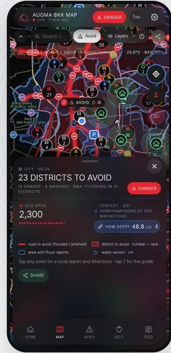
It is still being built, one layer at a time, from what people on the ground tell us they need. The next chapter is in the updates above.
A community tool, not an official warning. Emergencies: 1669 (medical) · 1784 (DDPM) · 1555 (BMA).